

Sea ice is the central player in a dynamic system that affects the planet’s oceans and climate. Sea ice is also a force to be reckoned with as polar waters open to human activity, such as shipping that is already taking place through the Northern Route along the coast of Russia and is potentially slated for the fabled Northwest Passage along the coast of Canada. Sea-ice motion, revealed in the data available here, is a critical factor in the thinning and melting of Arctic sea ice as it forms, rafts, ridges, and opens into leads and polynyas — and as winds and currents move it through and out of the Arctic.
 |  |
| Sea Ice Moves: Radar helps reveal the global effects of sea-ice motion. | Sea Ice in the Bering Strait: See an animation of synthetic aperture radar (SAR) images of the Bering Strait from 2007 and 2008. |
Dramatic changes: Though the extent of sea ice fluctuates, overall it is shrinking and substantially thinner than in past decades, and in spring and summer it is retreating earlier and faster. The melting, along with the absorption of solar energy by newly exposed, darker water, alters the circulations of oceans and the atmosphere, affecting climate and weather globally.
Observable through remote sensing: Remote sensing has been central to observing and researching changes in sea ice. Synthetic aperture radar (SAR), used to create the majority of the imagery available in the ASF archive, is among the power tools of remote sensing and has been used extensively in the science of sea ice. SAR bounces a microwave radar signal off the Earth’s surface, including water and ice, to detect physical properties. Unlike optical technology, SAR can “see” through darkness, clouds, and rain.
Critical for seafood: Sea ice also plays a substantial role in feeding the world. The ice serves as a farm for tiny organisms that drive the entire ecosystem. Seasonal sea ice in the Bering Sea is an integral part of an international fishery that provides more than half of the U.S. seafood catch. In addition, sea ice provides wildlife nurseries, molting sites, dens, hiding places, feeding grounds, resting platforms, and even transportation for Pacific walruses that migrate by riding on melting ice floes.
Sea-ice data, images, and data products available through the Alaska Satellite Facility (ASF) are supported under NASA’s Making Earth System data records for Use in Research Environments (MEaSUREs) program.
| Question | Answer | Additional information |
|---|---|---|
| What is Sea Ice? | The simple answer is that sea ice forms in the sea. | That’s when it starts to get interesting. |
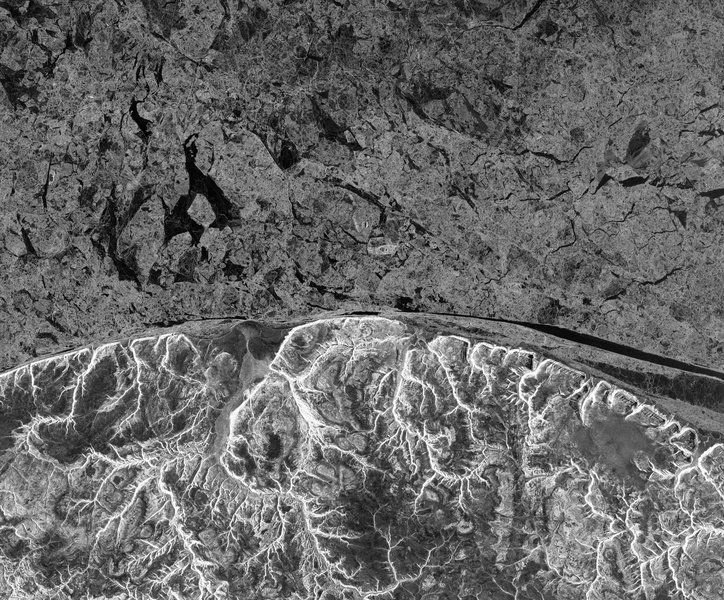
| What is Drift Ice? | Drift ice is not frozen to anything stationary, such as a shore, the ocean bottom, or grounded ice. In the Arctic Ocean, where drift ice can move as much as 10 km a day, winds and currents tend to transport the floating ice in two patterns. The Beaufort Gyre moves in a clockwise rotation in the Beaufort Sea, and the Transpolar Drift Stream (see map), flows from the Arctic Ocean toward the Atlantic. As Arctic sea ice has thinned in recent decades, its drift speed has tended to increase. | 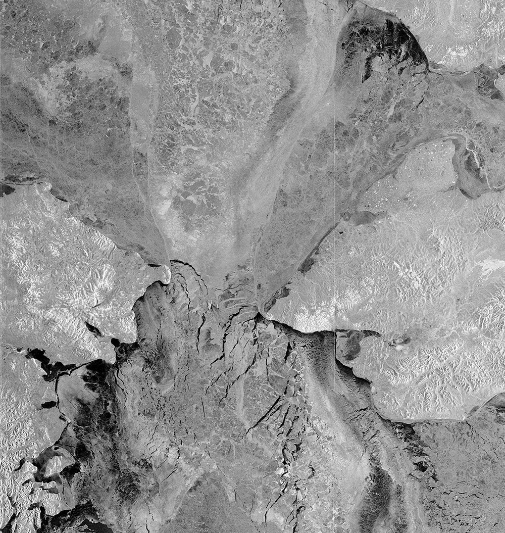 A synthetic aperture radar (SAR) image of the Bering Strait reveals ice, land, and water (black) in January. Radar sees through clouds and dark. Russia is on the left; Alaska is on the right.© CSA 2008[/caption] |
| What is Fast Ice? | Fast ice, sometimes called landfast ice, freezes to the shore, the ocean bottom, an ice wall, or a grounded iceberg. If it rises more than about two meters above sea level, it is called an ice shelf. | |
| What is First-Year Sea Ice? | First-year sea ice has lasted for no more than one winter, but it is thicker than the thin films of new ice called frazil, grease ice, and nilas. Although first-year ice ejects salt from its ice crystals in the freezing process, it still contains pockets of saltwater. If first-year ice survives to become multiyear ice, the saltwater eventually drains out, and the ice becomes denser. As Arctic sea ice has diminished in recent decades, first-year ice has become more prevalent than multiyear ice. | |
| What is a Sea-Ice Floe? | Sea-ice floes are individual pieces of sea ice 20 m or more across. | |
| What is Frazil? | Frazil is the start of sea ice — a collection of ice crystals that form a film on the water. As the crystals form, they eject salt into the surrounding water. The saltier the water, the heavier it is, so it sinks. The ocean becomes layered with sea ice on top of cold water, on top of heavier, saltier water. Those layers move in currents around the world, playing a large role in global climate. | |
| What is Grease Ice? | Grease ice is the next stage after frazil, when the ice crystals assemble in a syrupy layer. |  Grease ice occurs after frazil. © WHOI 2014. |
| What is an Ice Shelf? | Ice shelves are landfast sea ice (also known as fast ice) that rise more than about two meters above sea level. | |
| What are Lagrangian Sea-Ice Data Products? | Lagrangian sea-ice data products contain monthly measurements of dynamic and kinematic parameters over the Arctic Ocean sea-ice cover. “Lagrangian” refers to a mathematical way to study ice dynamics by noting changes in position and velocity of points over time. The sea-ice analysis in the dataset available here is initialized by laying a 10km-by-10km grid over a set of RADARSAT-1 images of the sea ice during an initial 3-day period of a season. The grid forms cells for which a number of properties can be derived that describe the sea-ice dynamics. The grid points of the sea ice and related cell properties are then tracked throughout the season. | |
| What is a lead? | Leads are long, linear areas of open water that develop as sea ice pulls apart, moved by winds or currents. A lead in sea ice can range from a few meters to over a kilometer in width and tens of kilometers long. Leads and polynyas (see below) are important for wildlife. The world’s population of spectacled eiders, for example, spends each winter in the northern Bering Sea, depending on the water in leads and polynyas when most other open water is frozen. | |
| What is a Sea-Ice Melt Pond? | Sea ice melt ponds form in depressions on top of the ice, deepening them. Because ice serves as a reflective surface that absorbs little solar energy, the darker water of melt ponds significantly warms both the ice and the atmosphere, accelerating the melting. |  Sea ice melt ponds accelerate melting. Credit: NASA 2011 |
| What is Multi-year Sea Ice? | Multi-year sea ice has survived at least two summers. Unlike first-year ice, multi-year sea ice is almost free of salt. In recent years, multi-year sea ice has become thinner. | |
| What is Pack Ice? | Pack ice is a term sometimes used to refer to particularly closely packed sea ice. It is sometimes used interchangeably with drift ice (see above). |  Pack ice off of Baffin Island, Canada. © 2013 Paul Gierszewski. |
| What is Pancake Ice? | Pancake ice consists of flat, circular pieces of sea ice that form from frazil and/or grease ice in rough water. They also can form below the surface. The edges of the “pancakes” are characteristically thickened from colliding in winds, waves, or currents in a sort of bumper-car effect. | |
| What is Polynya? | Polynyas, like leads (see above), are large open areas of water surrounded by sea ice — or by sea ice on one side and land on the other. Polynyas, however, are wide, not long and narrow. Polynyas and leads are important for wildlife. | |
| What is a Sea-Ice Pressure Ridge? | Sea-ice pressure ridges form when wind and currents press ice against sea ice, causing the sea ice to buckle and/or layer on top of itself. | |
| What is Sea-Ice Rafting? | Rafting takes place when winds or currents push pieces of sea ice on top of each other. | |
| What is RGPS? | The RADARSAT-1 Geophysical Processor System (RGPS) was designed to analyze the large volumes of SAR imagery required to produce basin-wide fields of sea-ice motion and estimates of sea-ice age and thickness from sequential RADARSAT-1 maps of the Arctic and Southern Oceans. From the RGPS, researchers have been able to obtain routine estimates of the seasonal sea ice produced by deformation of the sea-ice cover. | |
Applications
Sea ice is a key indicator of environmental change and is also a force to be reckoned with for humans navigating, drilling, or fishing in polar waters. At the northern end of the planet, where the Arctic’s oceans are largely constrained within landmasses — and the impact of climate change is more dramatic than anywhere else — sea ice serves as a particularly significant laboratory for monitoring our changing planet.
The data and imagery available from the Alaska Satellite Facility cover a period from 1995 to 2011. They include more than 11 years of near-uninterrupted, three-day radar snapshots of Arctic and Southern Ocean’s sea ice as it goes through dramatic change. Users may access:
- A dataset of small-scale kinematics and deformation processed by tracking sea ice on a high-resolution grid.
- The original synthetic aperture radar (SAR) images.
Uses
This dataset has already contributed significantly to sea-ice science in:
- new approaches for modeling the mechanical behavior of sea ice and the validation of these models;
- characterization of sub-daily ice motion;
- description of the seasonal and regional variability of sea-ice deformation;
- validation of ICESat freeboard algorithms; and
- estimates of sea-ice exchange between the Arctic and Southern Oceans and peripheral seas.
3 Case Studies
RGPS Melt Onset
The melt onset product consists of a gridded field containing the date of surface melt at each grid location. This date is derived from changes in the radar backscatter signature within the Lagrangian cells between April and June. The grid is at 10-kilometer resolution within the interior of the Arctic basin and 25-kilometer resolution near the coasts.
Summer 1998 Download | Summer 1999 Download
Citation
A study of the onset of melt over the Arctic Ocean in RADARSAT synthetic aperture radar data — R. Kwok, G. F. Cunningham, S. V. Nghiem. Journal of Geophysical Research, 108 (C11), 3363, DOI: 10.1029/2002JC001363.
RGPS SHEBA Ice Motion 1997-1998
These Eulerian Ice Motion products were produced by tracking ice-cover features on a 200-kilometer-by-200-kilometer area centered on the SHEBA ice camp. This observation site was established in November 1997 in the Beaufort Sea some 500 km off the north coast of Alaska and drifted with the ice pack for almost one year. This product is made with a cell spacing of 5 km resulting in a 41-by-41 element grid. The ice motion measurements were made on a near daily schedule covering two time periods from November 1, 1997 through December 25, 1997 and January 10, 1998 through October 6, 1998.
Download Data: November 1997-October 1998
CASES 2003-2004
These Eulerian Ice Motion products were produced for the Canadian Arctic Shelf Exchange Study (CASES) Project during the winter of 2003-2004. Displacements are derived from successive SAR images by tracking common features over a region off the Canadian coast, stretching out some 200 km from the middle of the Amundsen Gulf to the Mackenzie River delta. Grid spacing is approximately 22 km. The product dataset covers the dates of ice-covered conditions between November 3, 2003 and June 6, 2004.
Documents
- MEaSUREs Lagrangian and Eulerian Sea Ice Products: Product format specifications
- MEaSUREs Gridded Sea Ice Products: Product format specifications
- RADARSAT Geophysical Processor System Data User’s Handbook: Describes the background, procedures, and content of the Lagrangian data products
- RADARSAT Geophysical Processor System Product Specification: Provides the details and format of the data fields in the Lagrangian data product
An understanding of Arctic and Antarctic sea ice dynamics is accomplished by monitoring sea ice movement with SAR imagery throughout the year. The convergence of satellite orbits at high latitudes means that repeat coverage tends to improve near the North and South Poles. This permits complete coverage of the entire Arctic basin and Southern Ocean every three days. These three-day composite mosaics serve as a “snaphot” in time and are compared to similar snapshots in a temporal series.
Gridding
With the onset of each summer or winter season, a regular grid is superposed across the first snapshot of the seasonal series. The grid spacing is 10 km at high latitudes and 20 km near the Arctic and Antarctic perimeter. Monitoring sea ice movement consists of tracking the sea ice under each vertex in the regular grid. Sea ice exhibits structural characteristics based on its composition of first year and multi-year ice. The key to studying ice dynamics is tracking these characteristic features as the season evolves; allowing the regular grid to warp as the ice beneath each vertex moves.
Tracking
The tracking is an automated process that relies on feature extraction to find the common points in subsequent snapshots. However, the automated process is not perfect, necessitating human intervention for quality control. Operators correct the vertices when locations are misidentified and remove points from consideration when ice begins to break-up or the grid polygons lose their physical meaning.
For the sake of product nomenclature, it should be noted that we have adopted the Lagrangian frame of reference (as compared to the Eulerian). Instead of studying sea ice motion at a particular location over time, we follow individual ice parcels as they move through space and time. Lagrangian tracking is better-suited for the time evolving Arctic and Antarctic ice motion and can be readily manipulated to generate a number of sea ice products that will be described in the Products and Tools Section.
| Year | References Citing Sea Ice SAR Data |
|---|---|
| 2014 | Global satellite observation requirements for floating ice: Focusing on synthetic aperture radar – J.C. Falkingham, Environment Canada, World Meteorological Organization meeting (March 2014). A KPCA texture feature model for efficient segmentation of RADARSAT-2 SAR sea ice imagery – L. Xua, J. Liab, A. Wong, Cheng Wang. International Journal of Remote Sensing 35:13 (2014), 5053-5072, DOI: OI:10.1080/01431161.2014.933279. Landfast sea ice extent in the Chukchi and Beaufort Seas: The annual cycle and decadal variability – A. R. Mahoney, H. Eicken, A. G. Gaylord, R. Gens. Cold Regions Science and Technology 103 (2014) 41-56 DOI: http://dx.DOI.org/10.1016/j.coldregions.2014.03.003. The newest oldest data from Seasat’s synthetic aperture radar – T. Logan, B. Holt, L. Drew. Eos, Transactions American Geophysical Union, 95:11, 93–94, (18 March 2014), DOI: 10.1002/2014EO110001. Swell and sea in the emerging Arctic Ocean – J. Thomson, W. E. Rogers. Geophysical Research Letters 41, 3136–3140 (2014), DOI: 10.1002/2014GL059983. |
| 2013 | Arctic sea ice circulation and drift speed: Decadal trends and ocean currents – R. Kwok, G. Spreen, S. Pang. Journal of Geophysical Research: Oceans 118, 2408-2425 (2013), DOI: 10.1002/jgrc.20191. Sea ice monitoring by synthetic aperture radar – W. Dierking. Oceanography 26(2):100-111 (2013). Unsupervised classification of sea ice and water using synthetic aperture radar via an adaptive texture sparsifying transform – R. Amelard, A. Wong, D. A. Clausi, F. Li. IEEE International Geoscience and Remote Sensing Symposium, March 2013. Waveform classification of airborne synthetic aperture radar altimeter over Arctic sea ice – M. Zygmuntowska, K. Khvorostovsky, V. Helm, S. Sandven1. The Cryosphere 7(4) 1315-1324 (2013), DOI: 10.5194/tc-7-1315-2013 |
| 2012 | Wind-driven trends in Antarctic sea ice drift – P. R. Holland, R. Kwok. Nat Geosci.(2012), DOI: 10.1038/NGEO1627. Source and pathway of the Western Arctic upper halocline in a data-constrained coupled ocean and sea ice model – A. Nguyen, R. Kwok, D. Menemenlis, J. Phys. Oceanog. 42 (2012), DOI: 10.1175/JPO-D-11-040.1 Changing Arctic Ocean freshwater pathways – J. Morison, R. Kwok, C. Peralta-Ferriz, M. Alkier, I. Rigor, R. Anderson, and M. Steele, (2012), Nature, 481, 66-70, DOI:10.1038/nature10705. Arctic sea ice freeboard from IceBridge acquisitions in 2009: Estimates and comparisons with ICESat – R. Kwok, G. F. Cunningham, S. S. Manizade, W. B. Krabill (2012), J. Geophys. Res., 117, C02018, DOI:10.1029/2011JC007654. Deformation of the Arctic Ocean ice cover after the 2007 record minimum in summer ice extent – R. Kwok, G. F. Cunningham (2012), CRST, 76-77, DOI: 10.1016/j.coldregions.2011.04.003. Recent changes of arctic multiyear sea-ice coverage and the likely causes – I. V. Polyakov, J. Walsh, R. Kwok (2012), BAMS, DOI: 10.1175/BAMS-D-11-00070.1. Evaluation of Arctic sea ice thickness simulated by Arctic Ocean Model Intercomparison Project models – M. Johnson, A. Proshutinsky, Y. Aksenov, A. Nguyen, R. Lindsay, C. Haas, J. Zhang, N. Diansky, R. Kwok, W. Maslowski, S. Häkkinen, I. Ashik, B. de Cuevas, (2012), J. Geophys. Res., Vol. 117, DOI:10.1029/2011JC007257. |
| 2011 | Summer Antarctic sea ice as seen by ASAR and AMSR-E and observed during two IPY field cruises: A case study – AHMET E. TEKELI, STEFAN KERN, STEPHEN F. ACKLEY, BURCU OZSOY-CICEK, HONGJIE XIE, Annals of Glaciology 52(57) (2011) Comiso, J. C., R. Kwok, S. Martin, and A. L. Gordon (2011), Variability and trends in sea ice extent and ice production in the Ross Sea, J. Geophys. Res., 116, C04021, DOI:10.1029/2010JC006391. Drucker, R., S. Martin, and R. Kwok (2011), Sea ice production and export from coastal polynyas in the Weddell and Ross Seas, Geophys. Res. Lett., 38, L17502, DOI:10.1029/2011GL048668. Kwok, R. (2011), Observational assessments of Arctic Ocean sea ice motion, export, and thickness in CMIP3 climate simulations, J. Geophys. Res., DOI:10.1029/2011JC007004. Kwok, R. and J. Morison (2011), Dynamic topography of the ice-covered Arctic Ocean from ICESat, Geophys. Res. Lett., 38, L02501, DOI:10.1029/2010GL046063. Kwok, R. and N. Untersteiner (2011), The thinning of Arctic sea ice, Phys. Today, 64(4), 36-41. Kwok, R., and N. Untersteiner (2011) New High-Resolution Images of Summer Sea Ice, EOS Trans. AGU, 92(7), 53-54. Kwok, R. and G. F. Cunningham (2011), Deformation of the Arctic Ocean ice cover after the 2007 record minimum in summer ice extent, CRST, DOI: 10.1016/j.coldregions.2011.04.003. Kwok, R., B. Panzer, C. Leuschen, S. Pang, T. Markus, B. Holt, and S. Gogineni (2011), Airborne surveys of snow depth over Arctic sea ice, J. Geophys. Res., 116, C11018, DOI:10.1029/2011JC00737. Nguyen, A., D. Menemenlis, R. Kwok, (2011), Arctic ice-ocean simulation with optimized model parameters: Approach and assessment, J. Geophys. Res., 116, C04025, DOI:10.1029/2010JC006573. Farrell, S., T. Markus, R. Kwok, L. Connor (2011), Laser altimetry sampling strategies over sea ice, Ann. Glacio., 52(57), 69-76. Schweiger A., R. Lindsay, J. Zhang, M. Steele, H. Stern, and R. Kwok (2011), Uncertainty in sea ice volume, J. Geophys. Res., 116, C00D06, DOI:10.1029/2011JC007084. Spreen, G., R. Kwok, and D. Menemenlis (2011), Trends in Arctic sea ice drift and role of wind forcing: 1992-2009, Geophys. Res. Lett., 38, L19501, DOI:10.1029/2011GL048970. Toyota, K., J. C. McConnell, A. Lupu, L. Neary, C. A. McLinden, A. Richter, R. Kwok, K. Semeniuk, J. W. Kaminski, S.-L. Gong, J. Jarosz, M. P. Chipperfield, and C. E. Sioris (2011), Synoptic-scale meteorological control on reactive bromine production and ozone depletion in the Arctic boundary layer: 3-D simulation with the GEM-AQ model, Atmos. Chem. Phys., 11, DOI:10.5194/acp-11-3949-2011. van Angelen, J. H., M. R. van den Broeke, R. Kwok (2011), The Greenland Sea Jet: A mechanism for wind-driven sea ice export through Fram Strait, Geophys. Res. Lett., 38, L12805, DOI:10.1029/2011GL047837. |
| 2010 | Jay, C. V., M. S. Udevitz, R. Kwok, A. S. Fischbach, and D. C. Douglas. (2010). Divergent movements of walrus and sea ice in the northern Bering Sea, Marine Ecology Progress Series, 407:293-302. DOI: 10.3354/meps08575. Kwok, R. (2010), Satellite remote sensing of sea ice thickness and kinematics: A review, J. Glacio., 56, 200. Kwok, R. and G. F. Cunningham (2010), Contribution of melt in the Beaufort Sea to the decline in Arctic multiyear sea ice coverage: 1993-2009, Geophys. Res. Lett., 37, L20501, DOI:10.1029/2010GL044678. Kwok, R. and D. Sulsky (2010), Arctic Ocean sea ice thickness and kinematics: Satellite retrievals and modeling, Oceanography, 23(4): 134-143. Kwok, R., L. Toudal Pedersen, P. Gudmandsen, and S. S. Pang (2010), Large sea ice outflow into the Nares Strait in 2007, Geophys. Res. Lett., 37, L03502, DOI:10.1029/2009GL041872. Perovich, D., R. Kwok, W. Meier, S. Nghiem, J. Richter-Menge., (2010): The Arctic: Sea ice cover [in State of the Climate in 2009], Bull. Amer. Meteor. Soc., 91 (6), S88-S90. |
| 2009 | Kwok, R., and D. A. Rothrock (2009), Decline in Arctic sea ice thickness from submarine and ICESat records: 1958 2008, Geophys. Res. Lett., 36, L15501, DOI:10.1029/2009GL039035. Kwok, R., G. F. Cunningham, M. Wensnahan, I. Rigor, H. J. Zwally, and D. Yi (2009), Thinning and volume loss of Arctic sea ice: 2003-2008, J. Geophys. Res., DOI:10.1029/2009JC005312. Nguyen, A. T., D. Menemenlis, and R. Kwok (2009), Improved modeling of the Arctic halocline with a subgrid-scale brine rejection parameterization, J. Geophys. Res., 114, C11014, DOI:10.1029/2008JC005121. |
| 2008 | Kwok, R. (2008), Outflow of Arctic sea ice into the Greenland and Barents Seas: 1979-2007. J. Clim., 22(9), 2438 2457, DOI: 10.1175/2008JCLI2819.1. Lindsay, R. W., R. Kwok, L. de Steur, and W. Meier (2008): Halo of ice deformation observed over the Maud Rise seamount, Geophys. Res. Lett., 35, L15501, DOI:10.1029/2008GL034629. Kwok, R., E. C. Hunke, W. Maslowski, D. Menemenlis, and J. Zhang (2008): Variability of sea ice simulations assessed with RGPS kinematics, J. Geophys. Res., 113, C11012, DOI:10.1029/2008JC004783. Kwok, R., and G. F. Cunningham (2008): ICESat over Arctic sea ice: Estimation of snow depth and ice thickness, J. Geophys. Res., 113, C08010, DOI:10.1029/2008JC004753. Kwok, R. (2008): Summer sea ice motion from the 18 GHz channel of AMSR-E and the exchange of sea ice between the Pacific and Atlantic Sectors, Geophys. Res. Lett., 35, L03504, DOI:10.1029/2007GL032692. Zwally, H. J., D. Yi, R. Kwok, and Y. Zhao (2008): ICESat measurements of sea ice freeboard and estimates of sea ice thickness in the Weddell Sea, J. Geophys. Res., 113, C02S15, DOI:10.1029/2007JC004284. |
| 2007 | Kwok, R., G. F. Cunningham, H. J. Zwally, and D. Yi (2007): Ice, Cloud, and land Elevation Satellite (ICESat) over Arctic sea ice: Retrieval of freeboard, J. Geophys. Res., 112, C12013, DOI:10.1029/2006JC003978. Kwok, R., J. C. Comiso, S. Martin, and R. Drucker (2007): Ross Sea polynyas: Response of ice concentration retrievals to large areas of thin ice, J. Geophys. Res., 112, C12012, DOI:10.1029/2006JC003967. Kwok, R. (2007), Baffin Bay ice drift and export, 2002-2007: Geophys. Res. Lett., 34, L19501,DOI:10.1029/2007GL031204. Kwok, R. (2007): Near zero replenishment of the Arctic multiyear sea ice cover at the end of 2005 summer, Geophys. Res Lett., 34, L05501, DOI:10.1029/2006GL028737. Martin, S., R. Drucker, and R. Kwok (2007): The areas and ice production of the western and central Ross Sea polynyas, 1991-2002 and their relation to the B-15 and C-19 iceberg events of 2000 and 2002, J. Mar. Sys., 68, DOI:10.1016/j.jmarsys.2006.11.008. Coon, M., R. Kwok, G. Levy, M. Pruis, H. Schreyer, and D. Sulsky (2007): Arctic Ice Dynamics Joint Experiment (AIDJEX) assumptions revisited and found inadequate, J. Geophys. Res., 112, C11S90, DOI:10.1029/2005JC003393. Sulsky, D., H. Schreyer, K. Peterson, R. Kwok, and M. Coon (2007): Using the material-point method to model sea ice dynamics, J. Geophys. Res., 112, C02S90, DOI:10.1029/2005JC003329. |
| 2006 | Kwok, R., and M. D. Coon (2006): Introduction to special section: Small-Scale Sea Ice Kinematics and Dynamics, J. Geophys. Res., 111, C11S21, DOI:10.1029/2006JC003877. Kwok, R. (2006): Exchange of sea ice between the Arctic Ocean and the Canadian Arctic Archipelago, Geophys. Res. Lett., 33, L16501, DOI:10.1029/2006GL027094. Schreyer, H. L., D. L. Sulsky, L. B. Munday, M. D. Coon, and R. Kwok (2006): Elastic-decohesive constitutive model for sea ice, J. Geophys. Res., 111, C11S26, DOI:10.1029/2005JC003334. Kwok, R, (2006): Contrasts in Arctic Ocean sea ice deformation and production in the seasonal and perennial ice zones, J. Geophys. Res., 111, C11S22, DOI:10.1029/2005JC003246, 2006. Kwok, R., G. F. Cunningham, H. J. Zwally, and D. Yi (2006): ICESat over Arctic sea ice: Interpretation of altimetric and reflectivity profiles, J. Geophys. Res., 111, C06006, DOI:10.1029/2005JC003175. |
| 2005 | Kwok, R.: Variability of Nares Strait ice flux, Geophys. Res. Lett., 32, L24502, doi:10.1029/2005GL024768, 2005. Kwok, R.: Ross Sea ice motion, flux, and deformation, J. Clim., 18(18), 3759-3776, 2005. Kwok, R., W. Maslowski, and S. W. Laxon (2005): On large outflows of Arctic sea ice into the Barents Sea, Geophys. Res Lett., 32, L22503, doi:10.1029/2005GL024485. Cuny, J., P. Rhines, and R. Kwok: Davis Strait fluxes, Deep Sea Research I: Oceanographic Research Papers, 52(3), 519-542, 2005. Martin, S., R. Drucker, R. Kwok and B. Holt: Improvements in the estimates of ice thickness and production in the Chukchi Sea polynyas derived from AMSR-E, Geophys. Res. Lett., 32, L05505, doi:10.1029/2004GL022013, 2005. McPhee, M., R. Kwok, R. Robbins, and M. Coon: Upwelling of Arctic pycnocline associated with shear motion of sea ice, Geophys. Res. Lett. 32, L10616, doi:10.1029/2004GL021819, 2005. |
| 2004 | Kwok, R., H. J. Zwally, and D. Yi: ICESat observations of Arctic sea ice: A first look, Geophys. Res. Lett., 31, L16401, doi:10.1029/2004GL020309, 2004. Kwok, R.: Annual Cycles of Multiyear Sea Ice Coverage of the Arctic Ocean: 1999-2003. J. Geophys. Res., 109, C11004, doi:10.1029/2003JC002238, 2004. Kwok, R., G. F. Cunningham, and S. S. Pang: Fram Strait sea ice outflow, J. Geophys. Res., 109, C01009, doi:10.1029/2003JC001785, 2004. Martin, S., R. Drucker, R. Kwok and B. Holt: Estimation of the thin ice thickness and heat flux from SSM/I data for the Chukchi Sea Alaskan coast polynya for 1990 – 2001, J. Geophys. Res., 109, C10012, doi:10.1029/2004JC002428, 2004. |
| 2003 | Zhang, J., D. Thomas, D. Rothrock, R. Lindsay, Y. Yu, and R. Kwok: Assimilation of ice motion observations and comparisons with submarine ice thickness data. J. Geophys. Res., 108(C6):3170, DO1: 10.1029/2001JC001041, 2003. Wang, J., R. Kwok, F. J. Saucier, J. Hutchings, M. Ikeda, W. D. Hilbler III, J. Haapala, M . D. Coon, H. E. Markus Meier, H. Eicken, N. Tanaka, D. Prentki, W. Johnson: Working Toward Improved Small-scale Sea Ice Ocean Modeling in the Arctic Seas, EOS Trans. AGU, 84(34) 325-336, 2003. Kwok, R., G. F. Cunningham, and W. D. Hibler III: Sub-daily ice motion and deformation from RADARSAT observations, Geophy. Res. Lett,, 30(23), 2218, doi:10.1029/2003GL018723, 2003. Kwok, R., G. F. Cunningham, and S. V. Nghiem: A study of melt onset in RADARSAT SAR imagery, J. Geophys. Res., 108(C11), 3363, doi:10.1029/2002JC001363, 2003. Zhang, J., D. Thomas, D. Rothrock, R. Lindsay, Y. Yu, and R. Kwok: Assimilation of ice motion observations and comparisons with submarine ice thickness data. J. Geophys. Res., 108(C6):3170, DO1: 10.1029/2001JC001041, 2003. Wang, J., R. Kwok, F. J. Saucier, J. Hutchings, M. Ikeda, W. D. Hilbler III, J. Haapala, M . D. Coon, H. E. Markus Meier, H. Eicken, N. Tanaka, D. Prentki, W. Johnson: Working Toward Improved Small-scale Sea Ice Ocean Modeling in the Arctic Seas, EOS Trans. AGU, 84(34) 325-336, 2003. |
| 2002 | Kwok, R., and J. C. Comiso: Spatial patterns of Antarctic surface temperature: Connections to the Southern Hemisphere Annular Mode and the Southern Oscillation, Geophys. Res. Lett, 29(12), 10.1029/2002GL015415,2002. Kwok, R.: Sea ice concentration from passive microwave radiometry and openings from SAR ice motion, Geophys. Res. Lett, 29(10), 10.1029/2002GL014787, 2002. Kwok, R.: Arctic Ocean sea ice area and volume production: A contrast of two years – 1996/97 and 1997/98. Ann. Glacio. 34, 447-453, 2002. Kwok, R. and J. C. Comiso: Southern Ocean Climate and Sea Ice Anomalies Associated with the Southern Oscillation, J. Clim., 15(5), 487-501, 2002. Kwok, R. and G. F. Cunningham: Seasonal ice area and volume production of the Arctic Ocean: November 1996 through April 1997, J. Geophys. Res., 107(C10), 8038, 10.1029/2000JC000469, 2002. Richter-Menge, J. A., S. L. McNutt, J. E. Overland, and R. Kwok: Relating arctic pack ice stress and deformation under winter conditions, J. Geophys. Res., 107(C10), 8040, doi:10.1029/2000JC000477, 2002. Bardel, P., A. G. Fountain, D. Hall, and R. Kwok: Synthetic Aperture Radar Detection of the Snowline on Polar Glaciers, Taylor Valley, Antarctica, Ann. Glacio. 34, 177-183. Nghiem, S. V., D. K.. Perovich, A. J. Gow, R. Kwok, D. G. Barber, and J. C. Comiso: Observation of sea ice surface thermal states under cloud cover, JGR-Oceans. Nghiem, S. V., K. Steffan, R. Kwok, and W-Y. Tsai: Detection of snowmelt regions on the Greenland ice sheet using diurnal backscatter change, J. Glaciol., 47(159), 539-547, 2002. Wu, Xiaoping, M.M. Watkins, E.R. Ivins, R. Kwok, P. Wang, J.M. Wahr: Toward global inverse solutions for the determination of currrent and past mass variations: Contribution of secular satellite gravity and topography change measurements J. Geophys. Res., 107 (B11), 2291, doi:10.1029/2001JB000543, 2002. |
| 2001 | Kwok, R., M. Seigert, and F. D. Carsey: Ice motion over Lake Vostok, J. Glacio., 46(155), 689-694, 2001. Fahnestock, M.A., I. Joughin, T.A. Scambos, R. Kwok, W.B. Krabill, and S. Gogineni: Ice stream related patterns of ice flow in the interior of northeast Greenland, J. Geophys. Res., 106(D24), 34035-34045, 2001. |
| 2000 | Fahnestock, M. A., T. A. Scambos, C. A. Shuman, R. J. Arthern, D. P. Winebrenner, and R. Kwok: Snow megadune fields on the East Antarctic Plateau: extreme atmosphere-ice interaction Geophys. Res. Ltrs. 27(22), 3719-3722, 2000. Kwok, R.: Recent changes of the Arctic Ocean sea ice motion associated with the North Atlantic Oscillation, Geophys. Res. Lett, 27(6), 775-778, 2000. Siegert, M. J., R. Kwok, C. Mayer, and B. Hubbard: Water exchange between the subglacial Lake Vostok and the overlying ice sheet, Nature, 403(6770), 643-646, 2000. Siegert, M.J. and Kwok, R.: Ice-sheet radar layering and the development of preferred crystal orientation fabrics between Lake Vostok and Ridge B, central East Antarctica. Earth and Planetary Science Letters. 179 (2), 227-235, 2000. |
| 1999 | Joughin, I.R., M. Fahnestock, R. Kwok, R. Gogineni, and C. Allen: Ice flow of Humboldt, Petermann and Ryder Fletscher, northern Greenland, J. Glacio., 45(150), 231-241, 1999. Yueh, S. and R. Kwok: Arctic sea ice extent and melt onset from NSCAT observations, Geophys. Res. Lett., 25(23), 4369-4372, 1999. Kwok, R., G. F. Cunningham, and S. Yueh: Area Balance of the Arctic Ocean Perennial Ice Zone: Oct 1996- April 1997, J. Geophys. Res., 104(C11), 25747-25749, 1999. Kwok, R., G. F. Cunningham, N. LaBelle-Hamer, B. Holt, and D. A. Rothrock, Ice thickness Derived from high-resolution SAR imagery, Eos, Trans. AGU, 80(42), 495-497,1999. Kwok, R. and D. A. Rothrock, Variability of Fram Strait Flux and North Atlantic Oscillation, J. Geophys. Res., 104(C3), 5177-5189, 1999. |
| 1998 | Kwok, R., A. Schweiger, D. A. Rothrock, S. Pang and C. Kottmeier: Sea ice motion from satellite passive microwave data assessed with ERS SAR and buoy data, J. Geophys. Res.,103(C4), 8191-8214, 1998. Kwok, R., S. V. Nghiem, S. Martin, D. P. Winebrenner, A. J. Gow, D. K. Perovich, C. T. Swift, D. G. Barber, K. M. Golden and E. Knapp: Laboratory measurements of sea ice: Connections to microwave remote sensing, IEEE Trans. Geosci. and Rem. Sens. , 36(5), 1716-70, 1998. Kwok, R. and J. C. Comiso: The perennial ice cover of the Beaufort Sea from active and passive observations, Annals of Glaciol., 25, 376-381, 1998. Nghiem, S.V., R. Kwok, S. H. Yueh: Diurnal Cycling effects on the microwave signatures of thin sea ice, IEEE Trans. Geosci. Remote Sens., Vol. 36, No. 1, 111-124, 1998 Golden, K. M., D. Borup, M. Cheny, E. Cherkaeva, M. S. Dawson, K.-H. ding, A. K. Fung, D. Issacson, S. A. Johnson, A. K. Jordan, J. A. Kong, R. Kwok, S.V. Nghiem, R. G. Onstott, J. Sylvester, D. P. Winebrenner, I. H. H. Zabel: Inverse electromagnetic scattering models for sea ice, IEEE Trans. Geosci. and Rem. Sens. , 36(5), 1675-1704, 1998. Joughin, I. R., R. Kwok and M. A. Fahnestock: Interferometric estimation of three-dimensional ice-flow using ascending and descending passes, IEEE Trans. Geosci. Remote Sens., Vol. 36, No. 1, 1998. |
| 1997 | Yueh, S. R. Kwok, S. H. Lou and W. Y. Tsai: Sea ice identification using dual-polarized Ku-band scatterometer data. IEEE Trans. Geosci. Remote Sens. 35(3), 560-569, 1997. Joughin, I. R., M. Fahnestock, S. Ekholm and R. Kwok: Balance velocities of the Greenland ice sheet, Geophys. Rev. Lett., 24(23), pp. 3045-3048, 1997. Liu, A. K., S. Martin and R. Kwok: Tracking of ice edges and ice floes by Wavelet analysis of SAR Images, J. Atmos. Oceanic Tech., 14, 1187-1198, 1997. Nghiem, S., R. Kwok, S. Yueh, A. J. Gow, D. K. Perovich, J. A. Kong and C. C. Hsu: Evolution in polarimetric signature of thin saline ice under constant growth, Radio Science, Vol. 32, No. 1, pp. 127-151, 1997. Nghiem, S., S. Martin, D. K. Perovich, R. Kwok, R. Drucker, A. J. Gow, K. H. Ding, and J. A. Kong: A laboratory study of the effect of frost flowers on C-band radar backscatter from sea ice, J. Geophys. Res., 102(C2), 3357-3370, 1997. |
| 1996 | Kwok, R., J. C. Comiso and G. F. Cunningham: Seasonal Characteristics of the Perennial sea ice cover of the Beaufort sea. J. Geophys. Res., 101 (C12), 28417-28439, 1996. Kwok, R. and M. Fahnestock: Ice Sheet Motion and Topography from Radar Interferometry, IEEE Trans. Geosci. Remote Sens. Vol. 34, No. 1, 189-200, 1996. Comiso, J. C. and R. Kwok: Surface and radiative characteristics of the summer Arctic sea cover from multisensor satellite observations. J. Geophys. Res., 101 (C12), 28397-28416, 1996. Joughin, I., S. Tulaczyk, M. Fahnestock, R. Kwok: A Mini-Surgeon the Ryder Glacier, Greenland Observed via Satellite Radar Interferometry, Science, vol 274, pp. 228-230, 1996. Joughin. I, R. Kwok, M. Fahnestock: Estimation of Ice Sheet Motion Using Satellite Radar Interferometry: Method and Error Analysis with Application to the Humboldt Glacier, Greenland, J. of Glaciol., 42(142), 564-575, 1996. Joughin, I., D. Winebrenner, M. Fahnestock, R. Kwok, and, W. Krabill: 1996, Measurement of ice-sheet topography using satellite radar interferometry, J Glacio., vol. 42, no. 140, 1996. Nghiem, S. V, R. Kwok, J. A. Kong, R. T. Shin, S. A. Arcone and A. J. Gow: An electrodynamic model with distributed properties for effective permittivities of sea ice, Radio Sci., 31(2), 297-311, 1996. |
| 1995 | Kwok, R., D. A. Rothrock, H. L. Stern and G. F. Cunningham: Determination of Age Distribution of Sea Ice from Lagrangian Observations of Ice Motion, IEEE Trans. Geosci. Remote Sens., Vol. 33, No. 2, pp. 392-400, 1995. Kwok, R., S. V. Nghiem, S. H. Yueh: Retrieval of Thin Ice Thickness from Multi-frequency Polarimetric SAR Data, Remote Sensing of Environment, Vol. 51, No. 3, 361-374, 1995. Stern, H. L., D. A. Rothrock and R. Kwok: Open Water Production in Arctic Sea Ice: Satellite measurements and model parameterizations, J. Geophys. Res., 100 (C10), 20601-20612, 1995. Kwok, R. and T. Baltzer: The Geophysical Processor System at the Alaska SAR Facility. Photogramm. Engrg. and Remote Sens., Vol. 61, No. 12, 1445-1453, 1995. Nghiem, S. V., R. Kwok, S. H. Yueh and M. R. Drinkwater: Polarimetric Signatures of Sea Ice – Part I: Theoretical Model, J. Geophys. Res., 100(C7), 13665-13679, 1995. Nghiem, S. V., R. Kwok, S. H. Yueh and M. R. Drinkwater: Polarimetric Signatures of Sea Ice – Part II: Experimental Observations, J. Geophys. Res., 100(C7), 13681-13698, 1995. Hara, Y., R. G. Atkins, R. T. Shin, J. A. Kong, S. Yueh and R. Kwok: Application of Neural Networks for Sea Ice Classification in Polarimetric SAR Images, IEEE Trans. Geosci. Remote Sens., Vol. 33, No. 3, pp. 740-748, 1995.. |
| 1994 | Kwok, R and G. F. Cunningham: Backscatter Characteristics of the Winter Sea Ice Cover in the Beaufort Sea, J. Geophys. Res., 99 (C4), 7787-7803, 1994. Fetterer, F., D. Gineris and R. Kwok: Sea ice type maps from Alaska synthetic aperture radar facility imagery: An assessment, J. Geophys. Res., 99 (C11), 22443-22458, 1994. Lee, J. S., R. Grunes and R. Kwok: Classification of multi-look polarimetric SAR imagery based on complex Wishart distribution, Int. J. Remote Sensing, Vol. 15, No. 11, 2299-2311. Yueh, S., S. Nghiem and R. Kwok: Polarimetric scattering and emission properties of targets with reflection symmetry, Radio Science, Vol. 29, No. 6, pp. 1409-1420, 1994. Johnson, J. T., J. A. Kong, R. T. Shin, S. H. Yueh, S. V. Nghiem and R. Kwok: Polarimetric thermal emission from Rough Ocean Surfaces. JEMA, Vol 8, No. 1, 43-59, 1994. Yueh, S. H., S. V. Nghiem, R. Kwok, W. J. Wilson, F. K. Li, J. T. Wilson and J. A. Kong: Polarimetric thermal emission from periodic water surfaces, Radio Science, Vol 29, No. 1, 87-96, 1994. Kwok, R., E. Rignot, J. Way, A. Freeman and J. Holt.: Polarization Signatures of Frozen and Thawed Forests of Varying Environment State, IEEE Trans. Geosci. Remote Sens., Vol. 32, No. 2, pp. 371-381, 1994. Way, J., E. Rignot, K. C. McDonald, R. Oren, R. Kwok, G. Bonan, M. C. Dobson, L. A. Vierick, J. E. Roth: Evaluating the type and state of Alaska Taiga forests with imaging radar for use in Ecosystem models, IEEE Trans. Geosci. Remote Sens., Vol. 32, No. 2, pp. 353-370, 1994. |
| 1993 | Fahnestock, M., R. Bindschadler, R. Kwok, and K. Jezek: Greenland Ice Sheet Surface Properties and Ice Dynamics from ERS-1 Synthetic Aperture Radar Imagery, Science, Vol. 262, 1530-1534, 1993. Nghiem, S. V., S. Yueh, R. Kwok, and D. T. Nguyen: Polarimetric Remote Sensing of Geophysical Medium Structures, Radio Science, Vol 28, No. 6, 1111-1130, 1993. Nghiem, S. V., R. Kwok, J. A. Kong, and R. T. Shin: A Model with Ellipsoidal Scatterers for Polarimetric Remote Sensing of Anisotropic Layered Media. Radio Science, Vol 28, No. 5, 687-703, 1993. |
| 1992 | Nghiem, S., S. H. Yueh, R. Kwok, and F. K. Li.: Symmetry Properties in Polarimetric Remote Sensing. Radio Science, Vol 27, No. 5, 693-711, 1992. Jezek, K., J. P. Crawford, R. Bindschadler, M. Drinkwater, and R. Kwok: Analysis of Synthetic Aperture Radar Data Collected Over the Southwestern Greenland Ice Sheet. J. of Glaciology, Vol. 39, No. 131, pp 119-132. Kwok, R., E. Rignot, B. Holt, and R. G. Onstott: Identification of Sea Ice Type in Spaceborne SAR Data. J. Geophys. Res., 97 (C2), 2391-2402, 1992. Rignot, E. and R. Kwok: Spatial Statistics of Distributed Targets in SAR Image Data., Int. J. of Remote Sens., Vol. 14, No. 2, 345-363, 1993. |
| 1991 | Drinkwater, M., R. Kwok,, D. Winebrenner and E. Rignot: Multifrequency Polarimetry Synthetic Aperture Radar Observations of Sea-Ice. J. Geophys. Res., 96 (C11), 20,679-20,698, 1991. Rignot, E., R. Kwok, J. Curlander and S. Pang: Automated Multisensor Registration: Requirements and Techniques. Photogram. Engrg and Rem. Sens., Vol. 57, No. 8, August 1991, 1029-1038. McConnell, R., R. Kwok, J. Curlander, S. Pang and W. Kobe:, Ψ-S Correlation and Dynamic Time Warping: Two Methods for Tracking Ice Floes in SAR Images. IEEE Trans. Geosci. Remote Sens., Vol. 29, No. 6, pp. 1004-1012, 1991. |
| 1990 | Kwok, R., J.C. Curlander and S.S. Pang: An Automated System for Mosaicking Spaceborne SAR Imagery, Int. J. of Remote Sens., Vol. 11, No. 2, 1990, 209-223. Kwok, R., J.C. Curlander, R. McConnell and S. Pang: An Ice Motion Tracking System at the Alaska SAR Facility, IEEE J. of Oceanic Engineering, Vol. 15, No. 1, Jan 1990, 44-54. |
| 1989 and before | Kwok, R. and W.T.K. Johnson: Block Adaptive Quantization of Magellan SAR Data, IEEE Trans. Geosci. and Remote Sens., Vol. 27, No. 4, July 1989. Chang, C.Y., R. Kwok and J.C. Curlander: Spatial Compression of SEASAT SAR Imagery, IEEE Trans. on Geoscience and Remote Sensing, Vol. 26, No. 5, September 1988. Arvidson, R., M. Schulte, R. Kwok, J.C. Curlander, C. Elachi, J. Ford and R.S. Saunders: Construction and Analysis of Simulated Venera and Magellan Images of Venus, ICARUS, 75, 1988, 161-181. Kwok, R., J.C. Curlander and S. Pang: Rectification of Terrain Induced Distortion in Radar Imagery, Photogrammetric Engineering and Remote Sensing, Vol. 53, No. 5, May 1987, pp 507-513. Curlander, J. C., R. Kwok and S. Pang: A Post-Processing System for Automated Rectification and Registration of SAR Imagery, Int.l J. of Remote Sensing, 1987, Vol. 8, No. 4, pp 621-638. Friedmann, D.E., J.P. Friedel, K.L. Magnussen, R. Kwok, and S. Richardson: Multiple Scene Precision Rectification of Spaceborne Imagery with very Few Ground Control Points, Photogrammetric Engr. and Remote Sens. Vol. 49, No. 12, p. 1657, 1983. Evans, E. and R. Kwok: Mechanical Calorimetry of Large DMPC Vesicles in the Phase Transition Region, Biochem. 20:4874, 1982. Evans, E. and R. Kwok: Controlled Aggregation of PS-PC vesicles in Calcium, Biophy. J. 37:A165-A165, 1982 Kwok, R. and E. Evans: Thermoelasticity of Large Lecithin Bilayer Vesicles, Biophy. J. 35:637-652, 1982. Evans, E., R. Kwok and J.T. McKown: Calibration of Beam Deflection produced by Cellular forces in the 10-9 to 10-6 gram range, Cell Biophys. 2:99, 1980. |
To download the MEaSUREs Sea Ice products, use the Discover Data tab
Sea-ice imagery and data products are supported under NASA’s Making Earth System data records for Use in Research Environments program. These data have been used in a variety of applications.
Arctic and Southern Ocean imagery, data, and data products available at no cost from the ASF DAAC include:
- More than 11 years of RADARSAT-1, nearly uninterrupted, three-day radar snapshots of Arctic and Southern Ocean sea ice.
- Original synthetic aperture radar (SAR) images.
RADARSAT-1 data have been processed to:
- Construct a near-decadal record of small-scale ice motion of the Arctic and Southern Oceans.
- Produce a record of ice motion of the northern Bering Sea.
- Assemble monthly high-resolution image mosaics of the Arctic Ocean.
These datasets are available from the ASF DAAC and NASA’s Jet Propulsion Laboratory (JPL) through the project’s principal investigator, Ron Kwok. The original RADARSAT-1 images used to generate the products are available for download at no cost from the Alaska Satellite Facility datapool. Through ASF’s datapool, products such as Seasat, RADARSAT-1, ERS-1, ERS-2, JERS, and PALSAR sea ice images are free to approved users. To become an approved user, please submit the required Research Agreement. Additional sea ice data is offered through Polar Year 07-08, a part of the Global Inter-agency International Polar-Snapshot Year (GIIPSY), which contains satellite snapshots of polar regions.
MEaSUREs supports the NASA Earth-science research community in providing Earth science data products and services driven by NASA’s Earth-science goals. MEaSUREs projects focus on the creation of Earth System Data Records (ESDRs), including Climate Data Records. An ESDR is a unified and coherent set of observations of a given parameter of the Earth system that is optimized to meet specific requirements in addressing science questions.
These records are critical to understanding Earth system processes, assessing variability, long-term trends, and changes in the Earth system, and providing input and validation means for modeling efforts.
Explanation of the Data Product Terms
Lagrangian
The Lagrangian sea-ice data products contain monthly measurements of dynamic and kinematic parameters over the Arctic Ocean sea-ice cover. “Lagrangian” is a mathematical way to study ice dynamics by noting changes in position and velocity of points over time. The sea-ice analysis in the dataset available here is initialized by laying a 10km-by-10km grid over a set of RADARSAT images of the sea ice during an initial 3-day period of a season. The grid forms cells for which several properties can be derived that describe the sea-ice dynamics. The grid points of the sea ice and related cell properties are then tracked throughout the season.
Four data products result from these measurements:
1) Ice Motion – a record of the time and location of each point within the initial grid as tracked on RADARSAT images at approximately 3-day intervals. Note that a small fraction of the points may be lost during the season through advection out of the Arctic basin, loss of ice, or untrackability of the ice cover.
2) Deformation – a record of each cell’s divergence, vorticity, and shear. As the vertices of each cell move within a time step, the kinematic properties can be calculated to characterize the response of the ice cover to stresses induced by wind and ocean currents.
3) Ice Age and Thickness – a record of the area, age, and thickness of new and ridged ice resulting from cell area changes. A spatial and temporal distribution of these ice areas is kept for each cell. If the area of a cell increases within a time step, an area of new ice is created. The ice thickness within all the new ice areas created during the season is increased using air temperature information. The thinnest ice areas are rafted or ridged when the cell area decreases, depending on their thickness. The thickness of areas of ridged ice also grows over time.
4) Backscatter Histogram – a record of the radiometric properties of the ice within each cell. A histogram of the radar brightness is kept within each cell at each time step, allowing the user to deduce multi-year ice fractions of the ice cover.
Note that in earlier winter products, we use a 10km-resolution grid over the existing ice cover, beginning sometime near the beginning of November. In later products, we used a hybrid grid of 10km resolution over the multi-year ice pack and a 20km grid over the seasonal ice. We began our analysis in early December to permit the tracking of the seasonal ice regions.
3-Day Gridded
The 3-day gridded datasets are produced from the Lagrangian products. Parameters from the Lagrangian dataset are processed to produce fields with constant grid spacing. The gridded parameters are ice age, ice thickness, backscatter histogram, divergence, vorticity, and shear. Data values cover a 3-day period on a 12.5km-x-12.5-km grid. Each of the downloadable files contains one month of these 3-day product files.
Melt Onset
The melt onset product consists of a gridded field containing the date of surface melt at each grid location. This date is derived from changes in the radar backscatter signature within the Lagrangian cells between April and June. The grid is at 10km resolution within the interior of the Arctic basin and 25km resolution near the coasts.
Eulerian
Between 2008 and 2012, an archive of Envisat SAR imagery of the Arctic and Southern Oceans was created. In a project, conducted by Senior Research Scientist Ron Kwok of the Jet Propulsion Laboratory, the SAR imagery from Envisat was used to produce a high-resolution dataset of small-scale sea ice kinematics and deformation. This work is supported under NASA’s Making Earth System Data Records for Use in Research Environments (MEaSUREs) program. The motion field is sampled in Eulerian mode. The objectives are to:
- Process the Envisat data stream to construct ESDRs of small-scale ice motion of the Arctic and Southern Oceans;
- Develop products that take advantage of the temporal (daily observations) and spatial sampling scheme of the Envisat mission;
- Produce mosaics of the Envisat images of the Arctic Ocean and Southern Ocean.