Alaska Satellite Facility - Distributed Active Archive Center

JERS-1

Japanese Earth Resources Satellite artist rendering


The JERS-1 (Japanese Earth Resources Satellite) SAR is a high-resolution, all-weather imaging radar. JERS-1 was launched by the Japan Aerospace Exploration Agency (JAXA), aboard a Japanese H-1 launcher.  Its Global Forest Mapping Program mapped important forests of the world: Southeast Asia, Africa, Central America, South America (Amazon Basin), and Boreal North America. ASF distributes the Amazon and Boreal forest SAR mosaics.

NASA-logo
Logo of JAXA | Japan Aerospace Exploration Agency

JERS-1 Dataset Summary

Overview

Dataset PropertyValue
Temporal Coverage1992 - 1998
Repeat Cycle44 days
Spatial CoverageImagery coverage is worldwide
Datapool contains ASF standard beam odd frames, as well as the first and last frame of each imaged swath
Mosaics of global rainforests and the boreal forest
Center Frequency1.3 GHz L-band
PolarizationHH
Spatial Resolution18 m
Swath Width75 km
Off-Nadir Angle35°
Download infoData Discovery
File formatCEOS — Level 0 and Level 1 framed
ProviderJAXA
Date published:1992

Expand the sections below to view content.  Access the full content on a single page by clicking the button.

JERS 1 Coverage Map

JERS-1 Coverage Map

Mission

The JERS-1 (Japanese Earth Resources Satellite) SAR is a high-resolution, all-weather imaging radar. Its primary objective was gathering data on global land masses while conducting observation for land surveys, agriculture, forestry, fisheries, environmental protection, disaster prevention, and coastal surveillance.

Launch

JERS-1 was launched by the Japan Aerospace Exploration Agency (JAXA), aboard a Japanese H-1 launcher, to provide global and repetitive observations of the environment using techniques that allow imaging to take place in all weather conditions.

Achievement

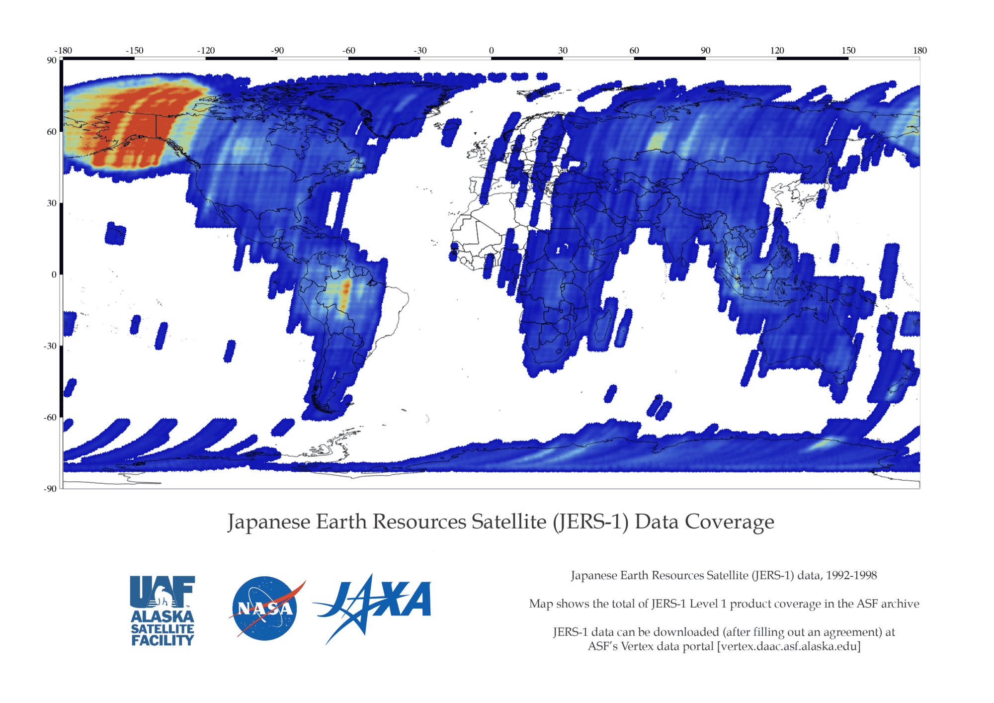
The JERS-1 Global Forest Mapping Program mapped important forests of the world: Southeast Asia, Africa, Central America, South America (Amazon Basin), and Boreal North America. ASF distributes the Amazon and Boreal forest SAR mosaics.

Datasets and DOIs
DatasetDOI
L0_JERS-110.5067/CRIS7FUD12QF
L1_JERS-110.5067/P882O8BV02R2

Downloadable Products

The Level 0 and Level 1 products are restricted datasets, and researchers must have permission to download data. Researchers must currently be living in the United States. For information contact the User Support Office.

Level 0 (Unprocessed/Raw Data)

Level 1 (amplitude imagery — processed images)

Mosaics — open access

    • Amazon Low Flood
    • Amazon High Flood
    • North America Winter Texture
    • North America Summer Texture
    • North America Summer Backscatter

How to Cite JERS-1 Data Retrieved from ASF DAAC

Dataset ProductHow to CiteFormatExample
JERS-1 DataCite data in publications such as journal papers, articles, presentations, posters, and websites. Please send copies of, or links to, published works citing data, imagery, or tools accessed through ASF to [email protected] with “New Publication” on subject line.Dataset: JERS-1, JAXA [year of data acquisition]. Retrieved from ASF DAAC [day month year of data access].Dataset: JERS-1, JAXA 1994. Retrieved from ASF DAAC 21 June 2015.
JERS-1 ImageryInclude credit with each image shown in publications such as journal papers, articles, presentations, posters, and websites.© JAXA [year of data acquisition]© JAXA 1994

Discover JERS-1 data

JERS-1 products can be accessed at ASF DAAC:


Data Discovery ToolLink
ASF Vertex Data SearchVertex
Python Search Moduleasf_search
ASF Search APIASF Search API
NASA Earthdata SearchEarthdata Search

Learn more about ASF Data Discovery Services