

Mapping Antarctica: On the 20th Anniversary of the Radarsat Antarctic Mapping Project
Kenneth C. Jezek
Professor Emeritus
Byrd Polar Research Center
School of Earth Sciences
The Ohio State University
Columbus, OH
Antarctica is one of the most remote and inhospitable regions of the Earth. Nevertheless, the Antarctic ice sheet, the underlying continent, and the surrounding ocean all play important roles in global climate and so have long been of interest to scientists and policy makers. For example, the ice sheet is a huge reservoir of fresh water with the potential to raise global sea level 10s of meters. The flow of the ice sheet into the sea is governed in part by the structure of the underlying continent. The seasonal formation of sea ice on the southern ocean is a key factor controlling deep ocean circulation. For those reasons, scientific investigation of Antarctica has been a high priority since the 1950’s. Of those investigations, mapping the Antarctic is the starting point for many scientific investigations.
While limited exploration of Antarctica occurred sporadically during the first half of the twentieth century, dedicated scientific studies began with the 1957 International Geophysical Year. Mapping was limited to areas that could be covered by arduous tractor-traverse and by aircraft. Continental scale mapping had to await the advent of satellites. National Oceanographic and Atmospheric Administration polar-orbiting satellites began obtaining optical images of the continent in the late-1970s, but these were of limited resolutions (kilometers) and suffered the obstructions of cloud and the long polar night. Surprisingly, and revealed publicly only in 1995, United States reconnaissance satellites began obtaining higher resolution (400 m) panchromatic images of the continent in 1963. Those images obtained at the start of the space age represent a unique, national treasure for studying how the continent has changed over the succeeding decades.
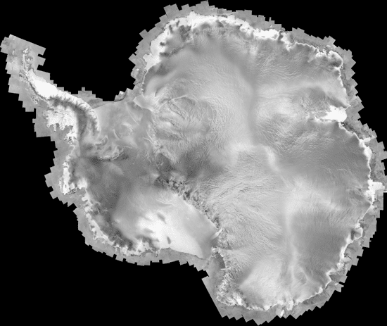
In an attempt to establish a geophysical benchmark of the entire continent including the South Pole at resolutions approaching 10 m, NASA and the Canadian Space Agency initiated a program to create a geodetic quality map of Antarctica using the Canadian Radarsat. Radarsat carried an imaging radar capable of satisfying the requirements to obtain high-resolution, day/night images over the relatively short time period of a few weeks. The Radarsat Antarctic Mapping Project (RAMP), led by The Ohio State University, The Alaska Satellite Facility, Vexcel Corporation, and The Jet Propulsion Laboratory, successfully completed that task in September of 1997 and released the first, complete, radar map of the continent. That map, in comparison with earlier maps including those compiled from the 1963/64 reconnaissance systems, has shown where the continental ice sheet has remained relatively stable (for example Queen Maud land which lies south of Africa) and where the ice sheet was retreating (primarily the Antarctic Peninsula). Because the imagery resolved very fine features, the map revealed previously unknown ice streams. One of these streams is equivalent to the length of the Mississippi from New Orleans to southern Illinois and drains ice from the interior Coates Land into the Filchner Ice Shelf. As importantly and following the primary mapping mission, the radar was operated in a novel mode called radar interferometry which allows for measurement of ice-sheet movement at the astonishing scale of only a few centimeters. The Radarsat observations followed earlier interferometric observations with the European Remote Sensing Satellite. Those repeat observations established where the ice sheet was speeding up or slowing down which is fundamental information for understanding the present state of the ice sheet and predicting how it will change in the future.
RAMP was a strong motivation for producing subsequent continental scale benchmarks. In 2000, Radarsat was again used to create a partial map of the continent with a focus on obtaining interferometric velocity data around the most dynamics parts of the ice sheet. The International Polar Year (IPY) of 2008 represented another important milestone when the community of space faring nations joined together in a dedicated study of the continent. By sharing resources to achieve important science goals, national space programs where able to obtain much finer measurements of ice sheet elevation and surface velocity which among other discoveries indicated significant thinning and retreat of glaciers draining into the Amundsen sea. ESA’s Envisat, Radarsat-2, the German TerraSar-X and the Japanese Earth Resources satellites were instrumental in achieving those goals. NASA’s ICESat, a laser altimeter system, obtained unprecedented topographic information about the ice sheet and exposed rock, which when measured repeatedly shows how the volume of the ice sheet is changing. As a contribution to the IPY, NASA’s Goddard Space Flight Center led the construction of a high resolution, optical mosaic map of Antarctica using Landsat data acquired between 1999 and 2003. NASA’s MODIS instrument was used during the IPY to construct a 2008-09 optical mosaic.
Repeated mapping of the surface of the continent remains a priority for the science community. But mapping for science means more than just studying the surface – the depths of the ice sheet (over 4 km thick in some places) and the physical composition of the underlying landmass are subjects of study. Until now, radio frequency radar has been used to successfully measure the thickness of the ice directly beneath the flight path of an aircraft. New techniques may, in the future, offer the possibility for constructing topographic and images maps of the land beneath the ice much like the maps of the surface. One approach, radar tomography, has been proven for small study areas but technical limitations still need to be overcome before large scale mapping can begin. Another promising technique relies on the thermally driven microwave radiation from within the ice sheet. Using radio receivers that sample many different frequencies, it may be possible to map the temperature field within the ice sheet. Such information is important because temperature strongly controls the rate at which the ice sheet flows.
Scientific mapping of Antarctica informs on several levels. First, those maps reveal how the continent is changing and how those changes will impact other regions of the Earth. Second, the sheer size of the continent means that a significant expenditure of resources is required to repeatedly measure those changes. Sharing resources amongst the international community is an effective and inspiring approach to securing the resources. Finally, the experience of mapping Antarctica is an important step in learning how to map other frozen worlds including the Martian ice caps and the icy moons of Jupiter and the outer planets.
Assorted Background
Bindschadler, R, P. Vornberger, A. Fleming, A. Fox, J. Mullins, D. Binnie, S. Paulsen, B. Granneman, and D. Gorodetzky, 2008. The Landsat image mosaic of Antarctica. Remote Sensing of Environment. vol 112, issue 12, p. 4214-4226.
M.Drinkwater, K. Jezek, E.Sarukhanian, T. Mohr, 2011. IPY Satellite Observation Program, Chapter 3.1 in “Understanding Earth’s Polar Challenges: International Polar Year 2007-2008”, Summary report by IPY Joint Committee, WMO/ICSU, p. 361-370.
Drinkwater, M.R., K. C. Jezek and J. Key, 2008. Coordinated satellite observations during the International Polar Year: Towards Achieving a Polar Constellation. Space Research Today, no. 171, p. 6-17
A. L. Gray, N. Short, K. E. Matter, and K. C. Jezek, Velocities and ice flux of the Filchner ice shelf and its tributaries determined from speckle tracking Interferometry. Can. J. Remote Sens., vol. 27, no. 3, pp. 193–206, Jun. 2001.
Jezek, K., 2003. Observing the Antarctic Ice Sheet using the RADARSAT-1 Synthetic Aperture Radar. Polar Geography, vol 27, no. 3, p. 197-209.
Jezek, K., X. Wu, P. Gogineni, E. Rodriguez, A. Freeman, F. Fernando-Morales, and C. Clark, 2011. Radar images of the bed of the Greenland Ice Sheet. Geophs. Res. Let., vol. 38, L01501, doi:10.1029/2010GL045519.
Jezek, K. C., J. T. Johnson, M. R. Drinkwater, G. Macelloni, L. Tsang, M. Aksoy, and M. Durand, “Radiometric approach for estimating relative change in intra-glacier average temperature,” IEEE Trans. Geosc. Rem. Sens., vol. 53, pp. 134-143, 2015
Kim, K., K. Jezek, and H. Liu, 2007. Orthorectified image mosaic of the Antarctic coast compiled from 1963 Argon satellite photography. International Journal of Remote Sensing, 28(23-24), p5357-5373.
Liu, H. and K. Jezek, 2004. A complete high-resolution coastline of Antarctica extracted from orthorectified Radarsat SAR imagery. Photogrammetric Engineering and Remote Sensing, vol. 70, no. 5, pp. 605-616.
Merson, R.H., 1989, An AVHRR mosaic of Antarctica. International Journal of Remote Sensing, 10, pp. 669–674.
Scambos, T.A., T. Haran, M. Fahnestock, T. Painter, and J. Bohlander, 2007. MODIS-based mosaic of Antarctica (MOA) data sets: continent-wide surface morphology and snow grain size. Remote Sensing of Environment, vol 111, issue 2-3, p. 242-257.
Williams Jr., R. and D. Hall, 1993. Glaciers. In Atlas of Satellite Observations related to Global Change, R.Gurney, J. Foster and C. Parkinson eds, Cambridge University Press, p. 401-422.
Thomas, R.H., 1993. Ice Sheets. In Atlas of Satellite Observations related to Global Change, R.Gurney, J. Foster and C. Parkinson eds, Cambridge University Press, p. 385-400.